In this digital world, geospatial data is everywhere. Try thinking about today without maps, how to get places, or weather news; confusing, huh? That’s what a world without geospatial data would be like. We increasingly use this data in our daily lives, and it’s essential to understand what it is and why we need it. This geospatial data is necessary for shipping, farming, development groups, and environmental checking. Whether you work with data or care about the environment, this geospatial data gives many different ways to understand what’s happening around you. In this blog, we’ll look at how location data is used in real-time and everything you need to know about it.
Geospatial Data
Geospatial data is information about things, happenings, or natural events on Earth’s surface. The location might be static (like where a road is, when an earthquake happens, or where kids live in poor conditions) or dynamic (like how a car or person moves, how sickness spreads, or where a forest fire is).
This data has the exact place and how different things and events connect. It’s usually used for making maps and studying them in geography, weather, and social studies.
Applications of Geospatial Data
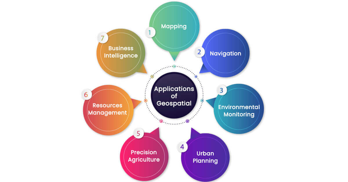
Geospatial Data has multiple applications in our daily activities, which are often overseen. Here are some of the applications:
Mapping
Geospatial data is used to make maps on our phones and GPS gadgets, like paper maps or digital ones. This information shows Earth’s surface features, like land shapes, roads, unique places, and where places start and end, in a very correct and detailed way.
For example, unique GIS map-making systems use this location data to create super precise and easy-to-use maps.
Navigation
Geospatial data is essential for navigation systems like GPS, which uses satellite information for exact location details. Thanks to coordinates from GPS satellites, GPS gadgets can figure out how long a trip takes and guide you turn by turn.
Also, this type of data can make navigation apps even better by giving traffic updates in real-time, proposing other ways to go, and showing nearby places you might want to go to, like eating spots, gas stations, and more.
Environmental Monitoring
Environmental monitoring collects and studies location data to assess risks, detect patterns, and help make informed decisions. This type of data gives a view from space to show how land areas have changed over time. This can be used to notice trends like cutting down forests, damage to the land, and city growth. This information can also help figure out water quality. Specialists use data from water bodies and how water reflects light to check for nutrients and pollutants, helping to understand the water-living world.
The location data also provides details about air quality, the movement of animal groups, and the impact of natural disasters. The use of this data for watching the environment is getting better and could help with worries about climate in the future.
Urban Planning
Geospatial data helps with building cities better. It is used in planning things like buildings, how transport works, and making smart choices about the city’s future. This data can be used to spot areas sensitive to the environment, like wetlands and forests. Geospatial data can encourage cities to think green by identifying ways that don’t harm the environment much, like areas with lots of sun and public transport.
By watching how cities change over time, we can better decide if planning rules are good by checking transport ways, buildings, and land use, making 3D models of cities, scanning for natural risks, mapping green spaces in cities, and weighing the effect of new buildings.
Precision Agriculture
Precision Agriculture means using location data and other tech tools to make crops grow better. By studying soil conditions, crop health, and weather, farmers can make smart choices about how to use land. Geospatial data can help farmers know how rich the soil is to pick suitable fertilizers and pesticides.
Technologies like GPS, remote sensing, and sensors help know the soil conditions, lack of nutrients, and temperature to create detailed soil maps. This data is used to watch crop quality over time, map how much is produced, save resources, and tackle pests and diseases. As tech continues improving, we can hope for more creative ways to improve farming.
Resources Management
Geospatial data helps us intelligently use Earth’s water, trees, and land resources. Checking on water supplies, reusable resources, and wildlife with real-time information is possible with this data. Geospatial data supports green energy solutions like windmills, solar farms, and oil fields.
One crucial part of managing resources is lowering disaster risks. Location data helps spot natural disasters like floods, earthquakes, and wildfires early. By studying location information, experts can understand the dangers, take steps to prevent harm, and plan how to respond, which can save lives and property.
Business Intelligence
Geospatial data adds more smarts to how businesses work. This data mixes information about what customers like, the marketplace, and where things happen. These vital details help businesses make marketing strategies and delivery choices. Location data helps improve delivery routes by checking traffic and ensuring customers are happy with timely arrival.
By studying market info, where competitors are, and what customers like in different areas, businesses can spot chances to grow, focus on the right customers, and change with the times.
Types of Geospatial Data
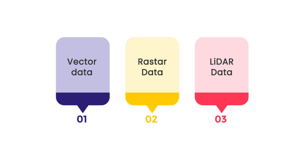
Geospatial data is often represented in maps, but this data is visualized in many types.
Vector data
Vector data is represented as points, lines, and polygons. Each point or line has a set of attributes that defines the characteristics of the location, event, and name. Vector data represents elements like buildings, rivers, and roads. This data is scaled to different levels by manipulating, editing, and making it suitable for many applications.
Raster Data
Raster data is a form of geospatial data that is represented in the form of images with grids and pixels. Each cell or pixel represents characteristics like land cover, temperature, and terrain elevations. It helps analyze geographical features applied in various environmental monitoring, urban planning, resource allocation, etc.
LiDAR Data
Light Detection and Ranging data is a point cloud data that is used to collect using laser screening. This mainly assists in capturing detailed topographic data, which is helpful in fields like construction and surveying. LiDAR can penetrate vegetation and canopy, making it essential for forest management and creating a detailed version of underlying terrains.
Tools & Software
Many tools are available to generate geospatial data to help make our daily activities more accessible and better. Here are some of the essential tools:
Remote Sensory Instruments
Remote sensory systems are designed to collect and process information from satellites, aerial photography, and LiDAR. This information is collected using cameras, Radad Sensors and LiDAR.
Ground-Based Sensors:
Ground-based sensors collect information from various sources like GPS locations, weather stations, and mobile parameters like air quality, soil conditions, and noise levels.
Geospatial Software
These are the software used to analyze and visualize the geospatial data. Geographic Information Systems, Remote Sensing Image Processing Software, and Cartographic software provide high-quality maps, layouts, designs, and symbolization of geospatial data.
Conclusion
In conclusion, geospatial data provides a meaningful explanation of the world around us. With the advancement of data collection and analysis tools, the use of geospatial data has grown and is only expected to expand. The invaluable data acquired from satellites, LiDAR, and remote sensors assist us in making informed decisions. Whether planning a greenhouse project or looking for a perfect location for your business, geospatial data does it all.
LocationsCloud is a leading data and insights enterprise that offers high-quality, accurate, and updated datasets at an affordable price. Level up your business solutions with our ready-to-use POI data.